
Nebelhorn
Nebelhorn Gipfel Terassen-SP 1 (südl. Gipfelstation) · Oberstdorf, Bayern, Germany · 30 flights a year · 30 in 30 days


About Nebelhorn
Oberstdorf's high alpine site: a cable car to launches up to 2,170 m, 1,340 m of height and strong thermals over the Allgäu Alps.
For advanced pilots- Cable car to launch at 2,170 m
- 1,340 m height difference to Oybele
- Five launches, SE to north
- ODV site briefing required
The Nebelhorn above Oberstdorf is high alpine terrain, run by the local club ODV. The cable car reaches the summit launch (2,170 m), 1,340 m above the Oybele landing. Summit launches need an unrestricted licence, lower launches are open to A-licence pilots too.
The Nebelhornbahn runs from Oberstdorf via Seealpe and Höfatsblick to the summit, with glider transport and pilot passes. The Geißfuß is a hike-and-fly launch with no lift.
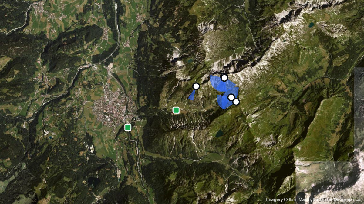
The terrace launch (2,170 m, 135°–200°) sits by the cable car – launch only with wind from the front. Lower launches: Probsthaus (1,905 m, 250°–270°), Zeigersattel (1,910 m, 240°–350°) and Geißfuß (1,949 m, SW only). The Oybele (830 m) is the main landing; the Seealpe is the safety field.
The north (valley) wind can spill over the ridge and create a dangerous lee to the south, where serious accidents have happened; avoid that area and fly above the north side of the Schattenberg. The south sides need a lot of experience: strong thermals, turbulence and sink.
You need at least an A licence, liability insurance and an ODV briefing; summit launches need an unrestricted licence. Guests pay a 5-euro fee. The south side of the Schattenberg below ridge level is closed year-round, plus seasonal zones; the ODV posts closures on WhatsApp.
Pilots fly here in summer and winter, with separate winter rules and a winter launch at the summit; in 2026 the Nebelhornbahn runs from late May to early November, and again from mid-December.
Facts last checked on 29 September 2026.
Imposante Lage in den hochalpinen Allgäuer Alpen. Geländeinformationen: https://www.odv-allgaeu.de/fluggebiet Die Fluggeländeordnung des Oberstdorfer Drachen und Gleitschirmfliegervereins ist dringend zu beachten! Rundum ist das Fluggebiet anspruchsvoll. Der Talwind kommt in diesem Gebiet aus Nord. Ab Mittag kann dieser den Kamm, der vom Geißfuß zum Nebelhorn zieht, überströmen. Es prägt sich südseitig dieses Kammes ein gefährliches Leegebiet aus. Hier ist es schon zu mehreren schweren Unfällen gekommen. Bei Talwind ist dieser Bereich zu meiden. Geflogen wird dann an oder über der Nordseite des Schattenberges.
1. Die Fluggeländeordnung des Oberstdorfer Gleitschirm- und Drachen e.V. ist dringend zu beachten. 2. Natur- und Wildschutz: Die Auflagen und Bedingungen sind allen Piloten bekannt zu geben und zu beachten.
When pilots fly here
Most flights start in September. Pilots usually launch between 13:00 and 16:00. Thermals here climb 0.8 m/s on average. Most thermals drifted in SW, SE wind.
From 30 flights the Open Glider Network saw start here in the last twelve months.
Pilot reviews
No reviews yet. Flown here? Tell other pilots how it went.
Step · Spot
Pick a launch: sites rated for the day, the most flown spots, valley wind, gusts and live stations.
Weather models
DWD ICON-D2 · 0.02° (~2 km)
Model guidance only. Terrain, launch conditions and winds aloft need a separate assessment.
Launches, landings and towing
Site
Hill site for paragliders · 1340 m height difference
Paragliders: 1- and 2-seaters
Seen launching (OGN): 4 flights today · 10 flights in 30 days
Access: Public transport · On foot
Oberstdorfer Drachen- und Gleitschirmflieger e.V. · Cable car: http://www.das-hoechste.de/sommer/bahnen/oeffnungszeiten/nebelhornbahn.html
Spots nearby
- HinangSchöllang, Bayern, Germany · 5.5 km away
- Grüner WegFischen, Bayern, Germany · 7.4 km away
- Imberger HornHindelang, Bayern, Germany · 7.7 km away
- IselerHindelang, Bayern, Germany · 10 km away
- WeiherkopfBolsterlang, Bayern, Germany · 12 km away
- SpieserHindelang, Bayern, Germany · 12 km away
- All spots around Oberstdorf